
Explorations Off the Beaten Paths
- Denise Dethlefsen

- Nov 27, 2025
- 4 min read
I always feel a bit sorry for folks who only stick to interstate highways and freeways when they're traveling. I've chatted with Colorado natives who'd never heard of some of the scenic byways right in their own state. Some were so focused on 'peak bagging' that they never

really thought about the highways and other roads they took to reach those peaks they climbed. They're missing out on so much!
When we're traveling for photography -- or really for any reason -- we try to explore places off the beaten paths. State highways, county roads, scenic byways, and backroads are much

more interesting to us, especially when they're two lanes or less, and have plenty of twists, turns, and moments of, "What might we find just over that hill?" There's more scenery, more wildlife, more wildflowers, more twists and turns, more ... everything.
I'll share some favorite pics from secondary and tertiary roads, trying not to repeat too many from previous posts.
Many of my photos come from exploring backroads and country roads. Some came about simply because we'd decided to explore a road we'd never traveled before. For example, this soapweed yucca (Yucca glauca) that we saw while we were on a ranch road in Wyoming has the best collection of flowers I've ever seen on these plants. I've been chasing yucca blooms for years, but they're like candy to deer and other animals, so the stalks are often fully denuded or have only a few intact flowers. Of course, there's also the fact that yucca frequently grow in places that aren't particularly photogenic.

We see ospreys (Pandion haliaetus) now and then, usually flying or perched high on a pole or dead tree. I'd never seen one resting in the water like this; it even hung around long enough for us to turn the car around so I could capture a photo more easily. It flew off seconds later. We couldn't decide whether it had just finished its meal, or was simply resting after a bath. The section of river where we saw the osprey runs close beside South Platte River Road, a gravel

road that’s a favorite among fishermen, located more than an hour's drive from Denver and Colorado Springs.
Finding sandhill cranes (Antigone canadensis) generally requires getting off more established roads. We saw this handsome pair from a side road on protected wetlands near Monte Vista, Colorado, during their spring migration.
Of course, landscapes from backroads and scenic byways can be pretty amazing. These are just a sampling: "Peaceful Little Pocket" was found as we traversed a remote ranch road about an hour's drive west of Glendo, Wyoming. We were intrigued by the biodiversity of this canyon with its small, but still

full, stream in an otherwise dry prairie habitat.
Some views happen so unexpectedly! This riot of wildflowers on a high-altitude plateau on Powder
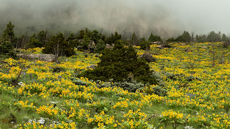
River Pass in the Bighorn Mountains of north- central Wyoming was a surprise. We'd been engulfed in rain and fog for several miles when the fog suddenly cleared to show meadows covered in yellow northern mule ears (Wyethia amplexicaulis), along with a few lupines (Lupinus sp.) and some small white wildflowers I couldn't identify.
On another occasion, we explored a remote backroad in a part of southwestern Colorado

that was scouted by people of European descent for the first time during the Dominguez-Escalante expedition of 1776-1777. Although the expedition never achieved its goal, the recorded maps, journals, and observations were invaluable to later explorers. And from the bits of the expedition trail we've found ourselves on over the past several years, those intrepid explorers covered some extremely difficult country through the Colorado Plateau, including parts of what are now Dinosaur National Monument, and Mesa Verde, Canyonlands, and Grand Staircase-Escalante National Parks.
We frequently go exploring just for the sake of it, such as venturing onto this small ranch road

off state Highway 9. The road led up to a high point that offers a sweeping view to the west toward the Buffalo Peaks Wilderness. East and West Buffalo Peak are ancient and heavily eroded volcanic peaks that are still higher than 13,300 feet and stand a little apart from the Mosquito Range. From the perspective of this photo, the Mosquito Range hides the Collegiate Range, located just to the west and behind them, above the small town of Buena Vista.
On a trip a couple years earlier, we found this view toward Mount Massive from Weston Pass Road (my husband swears he'll never drive that road again!). Weston Pass Road skirts the

eastern boundary of the Buffalo Peaks Wilderness area and reaches to nearly 12,000 feet in elevation; however, parts the road are extremely rough and our vehicle wasn't really the best choice for it. The ruins of numerous cabins and mines dating from the late 1800's can be seen

along the route. Earlier on the same trip, we discovered the view of the Clinton Gulch Dam Reservoir, seen at the top of this post, just north of Leadville on the way to Interstate 70 near Breckenridge.
Finally, this desert globemallow (Sphaeralcea ambigua) was found on the road shoulder along the Unaweep Tabeguache Scenic Byway in southwestern Colorado, not far from the tiny community of Naturita.
Hope you enjoyed this quick travelogue and some photos I've taken along the way. Check out more of my photo art on my website, www.denisedethlefsen.com, and if you'd like to buy, just click this link: Shop Art. Don't hesitate to email me with questions regarding sizing or media, comments, feedback, or just to say "Hi!"

Comments